https://www.darabanth.com/
https://static.darabanth.com/
https://static.darabanth.com/auction/img/
Continuous online auctions
Tétel

1896 Máramaros vármegye térképe, terv. Gönczy Pál, Pallas Nagy Lexikon...

The item is not available

Catalogue number:

12895.
369. Closed Online auction
Maps

Starting price:

2 000 HUF
5,31 EUR, 5,71 USD

Number of bids:

0

Description:

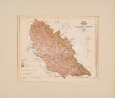
1896 Máramaros vármegye térképe, terv. Gönczy Pál, Pallas Nagy Lexikona, 1:680000, Bp., Posner Károly Lajos és fia, paszpartuban, hajtásnyommal, lap teteje és alja foltos, lap alájn apró szakadással, 22,5×27,5 cm / 1896, map of Maramures county, now part of Romania and Ukraine, in passepartout, spotty, with very small tear

Share:

Facebook

Photo of the item taken by : kozár_edit

further page navigation

Contact

Opening hours

  • Monday: 12-17
  • Tuesday-Wednesday: 10-17
  • Thursday: 10-19
  • Friday: closed
  • Weekend: closed

Our sites

© 2011-2024 Darabanth Philatelic and Numismatic Auctions Co., Ltd.
We use cookies on the Darabanth website to enhance your user experience.
By using this site you agree to the placement of cookies on your computer.
I agree
For details, please click here
https://www.darabanth.com/en/feltetelek/#privacy_policy
darabanth.com
Livestream

Item added to the basket

Basket cost in total:

Continue shopping
  To the payment