https://www.darabanth.com/
https://static.darabanth.com/
https://static.darabanth.com/auction/img/
Continuous online auctions
Tétel

cca 1802-1811 Arad vármegye (Comitatus Aradiensis) térképe, rajta: Ara...

Sold

Catalogue number:

17219.
438. Closed Online auction
Maps

Starting price:

15 000 HUF

Number of bids:

3

Description:

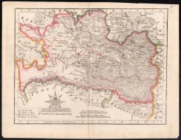
cca 1802-1811 Arad vármegye (Comitatus Aradiensis) térképe, rajta: Arad, Világos és más települések, színezett rézmetszet, papír, In: Görög Demeter (1760-1833) "Magyar Atlasz azaz a' magyar-, horvát- és tótországi megyék és szabad kerületek földképei", 22x29 cm, 28x21 cm, lap: 26x34 cm

Share:

Facebook

Photo of the item taken by : ekb

further page navigation

Contact

Opening hours

  • Monday: 12-17
  • Tuesday-Wednesday: 10-17
  • Thursday: 10-19
  • Friday: closed
  • Weekend: closed

Our sites

© 2011-2024 Darabanth Philatelic and Numismatic Auctions Co., Ltd.
We use cookies on the Darabanth website to enhance your user experience.
By using this site you agree to the placement of cookies on your computer.
I agree
For details, please click here
https://www.darabanth.com/en/feltetelek/#privacy_policy
darabanth.com
Livestream

Item added to the basket

Basket cost in total:

Continue shopping
  To the payment