We use cookies on the Darabanth website to enhance your user experience. By using this site you agree to the placement of cookies on your computer. I agreeFor details, please click here
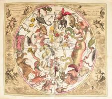
Andreas Cellarius (1596-1665) Haemispharium Stellatum Australe Antiquum - Az ókori déli csillagfélteke. Színezett rézmetszetű éggömb térkép, csillagtérkép. Megjelent Atlas Coelestis seu Harmonia Macrocosmica Amsterdam, 1708. Gereardum Valk - Petrum Schenk. Régi restaurálással. 504x432 mm, lapméret 560x476 mm / Andreas Cellarius (1596-1665) Haemispharium Stellatum Australe Antiquum - Ancient Southern Celestial Hemisphere Star Chart This celestial map is a creation of Andreas Cellarius, a renowned Dutch-German cartographer. It was originally published in the "Atlas Coelestis seu Harmonia Macrocosmica" in Amsterdam in 1708. The chart has been restored in the past centuries, 504x432 mm
2 Days 21:27:27 left{d<} {dn} {dl} {d>}{hnn}{sep}{mnn}{sep}{snn} left
Available
Starting price:
1 600HUF
4,18
EUR
,
4,51
USD
Number of bids:
0
My bid:
0HUF
Add to cart
Remove
3126211
16537
487
0
3200
Maps
Other collectibles
1
16537.
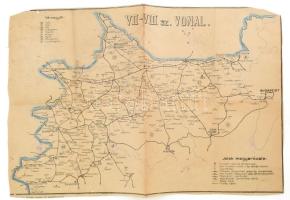
cca 1950 VII-VIII. sz. vonal (Északnyugat-Magyarország) vonalhálózati térkép, rajzolta: Stanek József, kissé viseltes állapotban, széle vágott, 57x38 cm
2 Days 21:27:27 left{d<} {dn} {dl} {d>}{hnn}{sep}{mnn}{sep}{snn} left
Available
Starting price:
1 600HUF
4,18
EUR
,
4,51
USD
Number of bids:
0
My bid:
0HUF
Add to cart
Remove
3333675
16540
487
0
6000
Maps
Other collectibles
1
16540.
Budapest balpart általános csatornázása. Bp., 1918. Székesfőváros házinyomdája. 86 p + 1 nagyméretű térkép, 1:50 000, M. kir. állami nyomda, 61×75 cm Kiadói .egyhén sérült papírkötésben
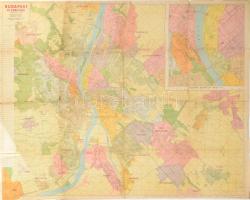
cca 1940 Budapest és környéke, összeáll. és rajzolta: Valentiny Károly, 1 : 25.000, (rajta Budapest belterülete, 1 : 10.000), óriás méretű térkép, Bp., Gergely R. Könyvkereskedés kiadása (Közlekedési-ny.), sérülésekkel, ragasztással javított, 93,5x124 cm
2 Days 21:27:27 left{d<} {dn} {dl} {d>}{hnn}{sep}{mnn}{sep}{snn} left
Available
Starting price:
3 000HUF
7,83
EUR
,
8,45
USD
Number of bids:
0
My bid:
0HUF
Add to cart
Remove
3332796
16543
487
0
10000
Maps
Other collectibles
1
16543.
[Bukarest térképe] ca 1920 Cauti Ghidul Socec - Planul orasului si al municipiului Bucuresti 110x90 cm Beszakadásokkal / Map of Bucharest with tears at folding
2 Days 21:27:27 left{d<} {dn} {dl} {d>}{hnn}{sep}{mnn}{sep}{snn} left
Available
Starting price:
5 000HUF
13,05
EUR
,
14,08
USD
Number of bids:
0
My bid:
0HUF
Add to cart
Remove
3335335
16545
487
0
4000
Maps
Other collectibles
1
16545.
cca 1800 Csanád megye térképe, rajta Arad, Szeged, Tótkomlós stb. Rézmetszet, papír, Berken metszése, jelzett a metszeten. Foltos. Üvegezett fakeretben. 12x18 cm
cca 1910 Tauril-Atlas I. Band. Automobil-Tourenkarte der Österreichisch-Ungarischen Monarchie. [Az Osztrák-Magyar Monarchia automobil-térképe.] 1 : 600.000. Herausgegeben von der Tauril-Pneumatik G.m.b.H. Wien und der Tauril-Pneumatik A. G. Budapest. [Unicus, több kötete nem jelent meg.] Bécs, é.n., Ed. Hölzel-ny., 2 sztl. lev.+ 6 p.+ 1 (átnézeti térkép) t.+ 50 (duplaoldalas, színes térképek) t.+ 2 sztl. lev. Többnyelvű jelmagyarázattal. Kiadói egészvászon-kötés, a gerincen sérüléssel, a térképek egy része kijár.


![[Bukarest térképe] ca 1920 Cauti Ghidul Socec - Planul orasului si al municipiului Bucuresti 110x90 cm Beszakadásokkal / Map of Bucharest with tears at folding](https://static.darabanth.com/images_thumbs/3/3/3332796.jpg)


![cca 1910 Tauril-Atlas I. Band. Automobil-Tourenkarte der Österreichisch-Ungarischen Monarchie. [Az Osztrák-Magyar Monarchia automobil-térképe.] 1 : 600.000. Herausgegeben von der Tauril-Pneumatik G.m.b.H. Wien und der Tauril-Pneumatik A. G. Budapest. [Unicus, több kötete nem jelent meg.] Bécs, é.n., Ed. Hölzel-ny., 2 sztl. lev.+ 6 p.+ 1 (átnézeti térkép) t.+ 50 (duplaoldalas, színes térképek) t.+ 2 sztl. lev. Többnyelvű jelmagyarázattal. Kiadói egészvászon-kötés, a gerincen sérüléssel, a térképek egy része kijár.](https://static.darabanth.com/images_thumbs/3/3/3333489.jpg)